
Gorges Has A Rich History
Imagine a land of abundant, clean water with more variety of plants and animals living together than nearly anywhere else on Earth. This is land with waterfalls around every corner. Pockets of water bubbling out of the sides of the oldest mountains on the planet. This is a land with four seasons, a rich native and post-native history, and immense opportunity for both science and recreation.
Now, imagine the trees cut down and harvested until the mountainside began falling in on itself. The rains dragged mud down from the peaks and filled the rivers with debris. Poisoned water and naked forests accent a cultural landscape found void of opportunity for its inhabitants.
Now, once more, imagine still a culture which recognized the importance of restoring and protecting those lands for the future generations. Acclaimed scientists and civilian conservationists working tirelessly to better understand these lands and its waters. The lands are healed and are placed in the care of a more informed, multi-purposed land management organization, and these protected lands now serve both the local and the national community year-round.
This story isn’t fictitious, nor is it a tale of some far away lands. In truth, this is a story repeated all across Appalachia starting before the colonization of the United States and developing more with every passing generation, year, and election cycle. Specifically, though, this is the story of Gorges State Park.Western North Carolina, and Southern Appalachia more generally, was largely seen as a land of resources throughout most of American history. Whether it was hunters bagging bear and deer, miners searching for coal, asbestos, and other manufacturable minerals, or loggers supplying housing materials throughout the entire Blue Ridge Escarpment, there were opportunities all throughout the region.
This extractive approach led to over-harvesting of local resources, and the then-naked mountainsides of Southern Appalachia faced immense erosion damage issues.
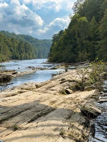
Lake Jocassee borders the southern end of Gorges State park. (Courtesy photo: Jacob Myers)
These water and logging issues, as well as the growing interest in the recreation industry, promoted interest in laying groundwork for a more conservation-based system of management in Appalachia in the 1880s. Tourism began growing as an industry, and it was the Weeks Act of 1911, signed by President William Taft, that truly gave name, funding, and protection to the national forests and public lands of Appalachia.
Pisgah National Forest, upon which Gorges would eventually share a boundary, was one of these newly designated national forests first managed and protected by one of America’s most renowned foresters, Gifford Pinchot.
While there was now a multi-use plan in place for large swathes of forest across North Carolina, which intended to sustainably harvest, study, and enjoy the forests for the foreseeable future, ecologically important sectors of Appalachia still lacked protections.
The Lake Toxaway dam burst in 1916 left a major scar that ruined homes and dug out the Toxaway River’s banks due to the sheer power of the flooding. Singer Sewing Company acquired much of this land as private land-owners were forced to sell off their parcels at a desecrated rate. The land was logged once again without the guidance of the USFS like the loggers operating within Pisgah, and the land once again suffered erosion issues.
After logging the land in the 1940s, it was sold to the Duke Energy Company, which recognized the opportunity for hydro-electric power on the steep mountainsides of the Blue Ridge Escarpment. Although Duke did limit public access to certain areas they maintained in the name of conservation, it was decided in 1982 that 275 acres of their land be placed in the N.C. Registry of Natural Heritage places so an organization with more conservation experience and resources could protect the rare species the land supports.
It was then in April of 1999 that Duke made a massive land transfer, which was the origin of Gorges State Park and the approximately 7,500 acres it serves.
Gorges, as well as all the N.C. State Parks, operate under the mission “to inspire all its citizens and visitors through conservation, recreation and education.” This mission is consistently served and reevaluated as the park continues to grow in visitation and development.
One need look no further than Gorges’ own visitor center as a centerpiece of conservation and education.
The center, completed in 2012, is placed upon an open ridge (open for a Southern Appalachian forest, anyways) where it harvests solar energy to help power the facilities.
“Thirsty concrete” on the upper parking area and other rain collection devices capture the region’s abundant rain and cycle it through the restrooms for flushing and to keep the center’s waterfall wall running. Geothermal heat is captured from deep underground to help keep the visitor center comfortable and warm in the colder seasons, and all this is concentrated in one, singular building!
Before even stepping inside the center, visitors can stop and enjoy kiosks which give a brief overview of the region, its climate, and the number of incredible spots one can hike or drive to within the park.
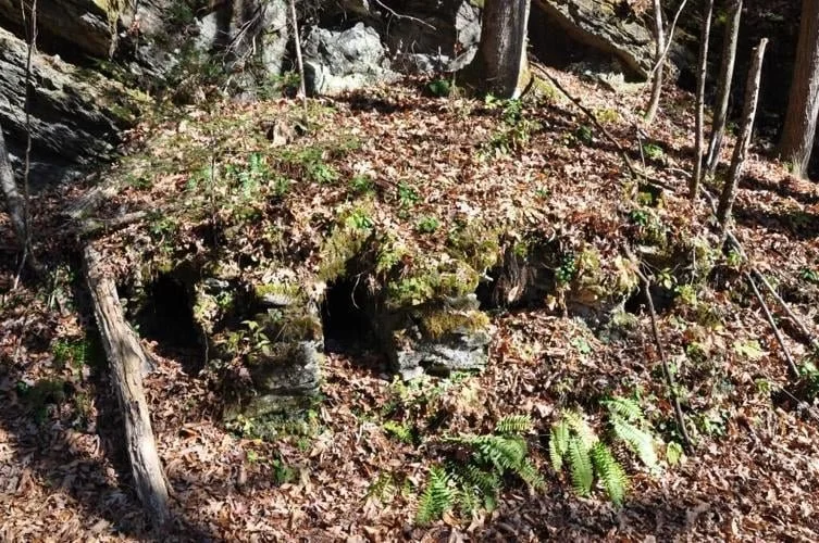
Lime kilns in Gorges State Park. Courtesy Photo: Kevin Bischof)
The real magic is what lies inside the center, however. Local animal skins lie in the classroom across the way from a series of exhibits where concepts like erosion, waterfall classifications, and river health are made approachable and interesting.
A few steps away lies a documentary about the park and its history, which plays on a loop throughout the year. Combine these learning opportunities with the information kiosks scattered throughout the park and the abundant knowledge of the park rangers and staff and visitors have a real opportunity approach the nuanced balance of recreation and conservation.
And speaking of recreation, Gorges definitely has it. Hiking trails, horseback riding, and fishing opportunities are among the most popular ways visitors can experience the park.
Trails run as far away and as low as Lake Jocassee on the 10-mile round trip Canebrake Trail, while some take visitors deep into the Auger Hole to historical, colonial-era lime kilns, and, of course, the ever popular Rainbow Falls trail.
The abundant rainfall in Gorges (classified as a genuine temperate rainforest) makes for very dynamic rivers that rise, fall, and roar at different times of the year, and this means a visit to Rainbow and Turtleback Falls, the parks two most popular vistas, look drastically different depending on the time of year.
Gorges continues into its 23rd year of operation with its mission still in mind. As visitation numbers steadily grow and the park looks to expand with more camping and recreation opportunities, it aims to do so in a way that will protect its precious waterways and abundance of biodiversity while educating visitors on the importance of those efforts.
Myers is an Appalachian-based adventure enthusiast and writer. He is an avid storyteller, and rarely does her or his fellow hikers step into the woods and return without something interesting to share. Most of his current writing is displayed on his blogger’s page on The Trek’s website.